วันเสาร์ที่ 17 มีนาคม พ.ศ. 2555

Travel in Songkhla Province


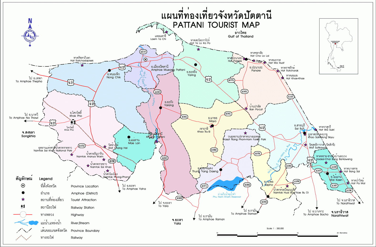
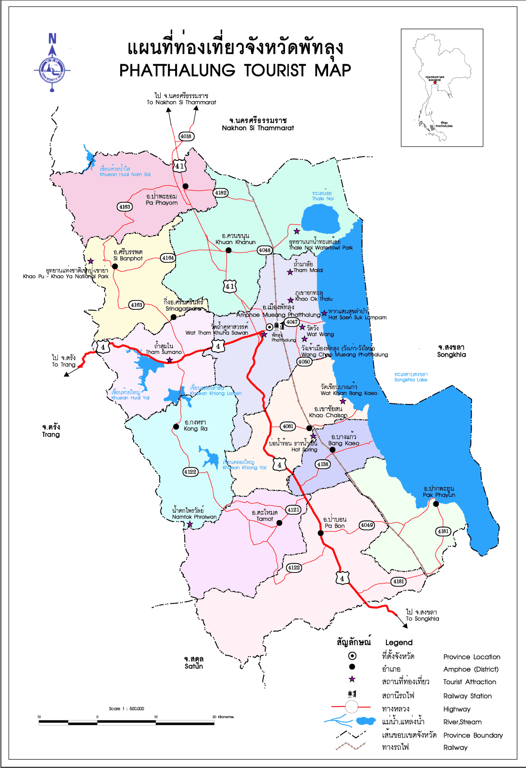
Songkhla is both one of Thailand's most important port cities and a coastal province known for its ethnic diversity and its unique traditions, dialect, and folk entertainment.

An outpost of the Srivijaya Empire from Sumatra (c. 7th century C.E.), Songkhla served as a port and a coastal trading post where Indian, Persian and Arabian merchants came to exchange their products. The city was named "Sing Lha" after the 2 lion-shape islands at the mouth of the city's lake. At present, these 2 islands are called Koh Noo (Rat Island) and Koh Maew (Cat Island). 
       
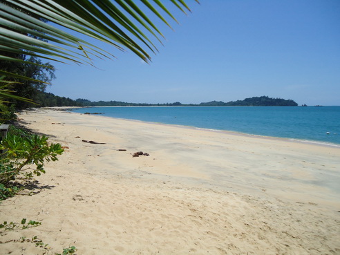
An undeniably historic town endowed with ancient ruins and places of cultural importance, Songkhla is a melting pot of Thais, Chinese and Malays, and charms visitors with its unique traditions, dialect, and folk entertainment. These characteristics are reflections of the province’s rich cultural heritage, which has been preserved and passed down from generation to generation.
       
Hat Yai, a district of Songkhla, is perhaps better known than the provincial capital itself. Hat Yai serves as a southern hub of communication, trading and transportation as well as a gateway to Malaysia and Singapore. In light of this, Hat Yai has gained importance as the driving force of economic growth in the southern region.
       
Over the last few decades, Songkhla has been rapidly developed and is currently a unique attraction worth visiting. Blessed with natural resources, such as fine beaches, enchanting waterfalls, and a tranquil lake, the province has an abundance of tourist attractions and an amazing number of seaside resort towns. Moreover, the old section of Songkhla still maintains its unique identity of ancient and historical flavors through local architecture and cuisine.
       
While Songkhla is noted as a fishing community set in a peaceful atmosphere, Hat Yai, on the other hand, serves as the transportation and communications hub of the south with links to various destinations in the neighboring provinces and Malaysia.


HOME
 

References

วันศุกร์ที่ 16 มีนาคม พ.ศ. 2555

Travel in Chumphon Province


With 200 kilometers of coastline, Chumphon features many beautiful and desolate beaches as well as some of the best diving and snorkeling on the gulf coast.
       
Chumphon province is located half way down the Isthmus of Kra, the narrow body of land flanked by Andaman Sea on the west and the Gulf of Thailand on the East; western Chumphon borders Myanmar, while the east of the province consist of more than 200 kilometers of coastline with numerous beaches that are infrequently visited by tourists. Consequently, Chumphon is an ideal destination for those who are seeking relaxation in a natural and quiet atmosphere.
       
Chumphon city, the capital of the province, is the gateway to other southern provinces as well as the islands in the Gulf of Thailand, particularly Koh Tao. While the area isn’t overrun with tourists there are still many opportunities for sunbathing, swimming, yachting, paragliding, diving, and snorkeling.
       
Historical documents state that Chumphon was continuously inhabited by various communities since the pre-historic period, especially in the area along the banks of the Tha Taphao River. Chumphon was also one of the leading trading centers of Siam (Thailand prior to the Second World War).
       
As a frontier city, Chumphon is believed to have derived its name from Chumnumphon, which means the accumulation of forces. Whenever there were movements of the army, the soldiers would gather their forces here in this province. Other sources argue that the name is derived from a local plant named Maduea Chumphon, which is abundant in this area. This plant has become a symbol of Chumphon Province.


Chumphon city, the capital of Chumphon province, is the gateway to Thailand’s southern provinces as well as the islands in the Gulf of Thailand, particularly Koh Tao. With more than 200 kilometers of coastline featuring numerous unspoiled beaches, Chumphon is an ideal destination for those who are seeking relaxation in a natural and quiet atmosphere and wish to enjoy such activities as sunbathing, swimming, yachting, paragliding, diving, and snorkeling. 


HOME


References

Travel in Krabi Province


Krabi, a province on southern Thailand’s Andaman coast, is an almost otherworldly region of labyrinthine archipelagos, where islands seem to erupt vertically out of the sea and secluded beaches are only accessible by colorfully adorned long tail boats. Krabi’s myriad of bays and coves have sheltered pirates, merchants, and sea gypsies for thousands of years and archaeological evidence indicates that Krabi was originally inhabited as early as 25,000 - 35,000 years ago!
       

With attractions including hot springs, a wildlife sanctuary, sea caves, flourishing coral reefs and exotic marine life, limestone cliffs that draw rock climbing enthusiasts from around the world, and national parks that include the island paradises of Koh Phi Phi and Koh Lanta, one could easily spend weeks in Krabi and leave yearning for more.
       

If that wasn’t enough, Krabi features some of the most photogenic sunsets in Thailand, often accompanied by spectacular displays of cloud to cloud lightning, that are best enjoyed from a beachside bar or restaurant.
       

Meanwhile, with all the tourists spread out among various beaches and islands, life goes on in Krabi Town, the somewhat sleepy provincial capital. Surprisingly few tourists spend time in the charming riverside town, whose hilly streets feature a number of cozy cafes and inexpensive and authentic Thai cuisine is served at an outdoor, riverside evening market.
       

“Town” to most visitors is Ao Nang, a seaside strip of guesthouses, hotels, bars, restaurants, and souvenir shops that continues to grow as tourist arrivals increase, now spreading north into Noppharat Thara, whose quiet, shady beach is part of the national park that includes the Phi Phi Islands. Ao Nang is the major launching point for boat trips to nearby islands and the isolated beaches of Phra Nang Cape, where the famous former hippie enclave of Railey Beach is located.
       
Krabi Province, which lies along the coast of the Andaman sea in Southern Thailand, is a top tourist destination as a result of its plentiful natural attractions including, white sandy beaches, crystal clear water, extensive coral reefs, numerous caves and waterfalls, and over 130 islands, including Koh Lanta and the jewels of the Andaman coast, the six islands of Mu Koh Phi Phi National Park.
       

While not the top destination in and of itself, Krabi Town is a charming provincial capital located along the banks of a river that leads to the nearby Andaman Sea. Consequently, Krabi is an important port city for both local fisherman as well as boats ferrying visitors to the nearby attractions, including Koh Phi Phi, Koh Lanta, and Railey Beach, one of the premier rock climbing destinations in the world. 


WHERE TO TRAVEL 

Ao Nang Ao Nang, located 6 km. from Hat Noppharat Thara, is a large bay with scenic beaches and 83 small islands. A number of hotels and bungalows as well as dive shops are available.


Mu Ko Phi Phi  Now famous as the location for the movie The Beach, there are two principal islands in the Phi Phi group, Phi Phi Don and Phi Phi Le. The former is larger and has been developed with bungalow accommodation and other tourist facilities. Phi Phi Le, smaller and uninhabited, is stunningly beautiful with sheer cliffs, idyllic bays, hidden coves and caves.


Mu Ko Lanta National Park Several different islands are encompassed by the park, some of which are surrounded by beautiful coral reefs, while the main island of Ko Lanta Yai is an up-and-coming resort destination.


Hat Nopparat Thara This is a long and fairly plain beach by Krabi’s high standards, but it’s a popular location with locals for picnics and days out because of the shade afforded by the trees. There are a few guest-house and bungalow style operations that tend to be more popular with the backpacker community. As with just about anywhere in Krabi, the views here are beautiful


Maya Bay  Maya Bay is amongst the most photogenic of Thailand’s beaches. The natural beauty of the area is undeniable with towering limestone cliffs, clear waters, coral reefs and a white sandy beach. It is also located on uninhabited Phi Phi Leh so in theory ticks all the boxes for the perfect hideaway, tropical beach paradise. However, it is these same reasons that means Maya Bay is no longer a secluded paradise and on a daily basis, dozens of boats carrying day-trippers from Phuket and Krabi descend on the beach here


HOME


References

Travel in Nakhon Si Thammarat Province


       Nakhon Si Thammarat, the second largest province in southern Thailand, lies 780 kilometers south of Bangkok along the Gulf of Thailand within the lush interior of the Isthmus of Kra. Nakhon Si Thammarat played an important role in the history of Thailand, including its role as an important center of Thai Buddhism perhaps as early as the Srivijaya Period or earlier in the 3rd century C.E. Nakhon Si Thammarat was also a major region of trade between merchants from the Indian, Arabic, Dvaravati, and Champa states and later for merchants from British, Portuguese and Dutch empires.
       In addition to its great history, Nakhon Si Thammarat boasts many undeveloped beaches as well as two national parks within an interior of verdant jungles abundant with luxuriant vegetation, beautiful waterfalls, and exotic wildlife.
       Nakhon Si Thammarat city contains many Muslim, Buddhist and Hindu temples and is an excellent place to see a performance of Thai nǎng tàlung featuring handmade shadow puppets, a performance art the region is famed for. In fact, both Thai nǎng tàlung (shadow play) and lákhon (Thai classical dance-drama) art forms were developed in Nakhon.


       Nakhon Si Thammarat, the second largest province in the south, lies 780 kilometers south of Bangkok. The capital of Nakhon Si Thammarat is one of the most ancient cities in Thailand, formerly the capital of the Kingdom of Ligor, which was an independent kingdom for many centuries and a historical center of Buddhism in ancient Thailand. Today Nakhon Si Thammarat is renowned for its shadow puppets, its beautiful countryside, and its beautiful and diverse temple architecture.


HOME


References

Travel in Narathiwat Province


Narathiwat is a province on the coast of the Gulf of Thailand at the border of Malaysia; its people are engaged in fishing and trading with neighboring countries and the province has a white elephant called Phra Sri Nararat Rajakarin, who is featured on the provincial seal.
        
Located approximately 1,150 kilometers south of Bangkok, Narathiwat is the southernmost province in Thailand where it is one of five that border Malaysia, in this case at Amphoe Su-ngai Kolok, where the southern railway line ends.
       
With Amphoe Su-ngai Kolok serving as an economic and border tourism center, the province welcomes an increasing numbers of Malaysians and Singaporeans on short holidays or shopping sprees.
       
In 1915, King Rama VI bestowed the name “Narathiwat,” meaning “home of good people” on the province that has a constant flow of trade and a fusion of cultures the majority whom are Muslims who speak the distinctive Yawi language.
       
In addition to its cultural attractions, Narathiwat has beautiful beaches and is the region where most Thai gold is mined.Located approximately 1,150 kilometers south of Bangkok, Narathiwat is the southernmost province in Thailand where it borders Malaysia. Consequently, Narathiwat draws many Malaysians and Singaporean visitors and features a distinct culture featuring many Muslim Thais. Seventy five percent of Narathiwat is covered with jungles and mountains, there are numerous beaches, and there a number of magnificent temples to visit.


HOME


References

Travel in Pattani Province


Pattani is a small Province with irresistible charm, rich in historical significance and distinctive customs and traditions as a result of its ethnic diversity and wonderful hospitality; Pattani also has natural scenic beauty that includes rivers, streams, and waterfalls as well as long golden beaches along the Gulf of Thailand.
       
Pattani is both the name of the province in the south of Thailand and the city that is its capital. Pattani contains two major rivers, the Tani and Sai Buri and covers a relatively flat region with a long coastline that runs 170 kilometers along the Gulf of Thailand.
       

Pattani still maintains the ruins of an ancient town in Amphoe Yarang that once served as an important port and center of administration, trade, and culture for many centuries. Attractions in modern-day Pattani include unspoiled nature, numerous historical sites, and a traditional culture, which has benefited from the integration of Thai, Chinese and Islam settlers.
       
Pattani contains two major rivers, the Tani and Sai Buri and a long coastline along the Gulf of Thailand. Pattani still maintains the ruins of an ancient town in Amphoe Yarang and other attractions include unspoiled beaches, several historical sites, and a distinct culture, consisting of Thai, Chinese and Malay ethnic groups. 


HOME


References

Travel in Phang Nga Province


Phang Nga province is blessed with a variety of outstanding natural attractions including the stunning Phang Nga Bay, the idyllic Surin and Similan Islands, the sandy coast of Khao Lak, and  Phang Nga is a province equally renowned for its beautiful land, spectacular bay, and amazing islands; Phang Nga national parks feature magnificent scenery with immensely different attractions. Most famous is Phang Nga Bay National Park, a geological wonder filled with islets, sunken caverns, and startling rock formations rising vertically out of the sea. The bay is extremely sheltered and therefore ideal for expeditions on sea kayak that explore the many fascinating caverns and islands throughout the bay. 
       
Phang Nga's Andaman coast offers equally stunning national parks of a different kind; the island groups of Surin and Similan are renowned for their beautiful, unspoiled beaches and spectacular underwater scenery, attracting divers from around the world. On the Phang Nga mainland, Khao Lak features a coastal park full of rare birds, exotic mammals, and scenic waterfalls, as well as many luxury and budget hotels along the spectacular coast that was devastated by the 2004 Tsunami but has since been completely rebuilt.
Not to be confused with Koh Phangan, the island in the Gulf of Thailand, Phang Nga province lies on the Andaman coast on the Thai mainland immediately north of  Phuket.
       

Phang Nga is renowned for its spectacular beauty, particularly Phang Nga bay, which contains hundreds of island including Koh Tapu (James Bond Island), where the film The Man with the Golden Gun was shot, and Koh Yao Noi and Koh Yao Yai, which feature laid back communities that allow for cultural home stay experiences. Phang Nga is also the province that includes two groups of islands considered the most beautiful in Thailand: Mu Koh Similan and Mu Koh Surin National Marine Parks.
       

Along Phang Nga’s Andaman seashore lies Khao Lak, a stunning coastline of expansive beaches that bore the brunt of the 2004 Tsunami but has greatly recovered, and -- these two islands are little visited, yet well worth the effort. Although part of Phang Nga province, they are best visited from either Phuket or Krabi provinces. The big attraction in the bay is the spectacular karst scenery that is found through out the north of the bay. 


WHERE  TO  TRAVEL 

Ao Phang-nga Designated a marine national park in 1981, Ao Phang-nga covers a coastal and offshore area. Mangrove forests are found along the shoreline. However, the most striking feature is the bay, which is dotted with more than 100 islands, weirdly shaped limestone outcrops swathed in tangles of creepers, shrubs, and mostly uninhabited. Some rise sheer from the water, others are humped or jagged and all present a haunting aspect. Many have notable features, such as Khao Khian, where prehistoric rock paintings can be seen on the cliffs; Ko Panyi where there is a Muslim fishing village built on stilts; Ko Phanak with beautiful caves, and “James Bond Island” which is famous for the location of the movie “ The Man with the Golden Gun.” 


Mu Ko Similan Mu Ko Similan are also preserved as a national marine park, extending over an area of 32,000 acres. Set in the Andaman Sea about a 3-hour boat ride from the mainland, the nine islands of the archipelago are quite distinct from those of Phang-nga. The islands are of granite, not limestone which makes them a rare beauty. The formations are also uniquely different. Together with hiking trails and other onshore attractions, however, Similan’s reputation is its 30 excellent and dissimilar diving sites. Coral walls, huge sea fans and barrel sponges, rock reefs, swim-throughs and other underwater features offer a wide variety of opportunities for experiencing, while plenty of shallows afford excellent conditions for snorkelling.


Mu  Ko Surin This National Marine Park, comprising five islands and covering more than 33,000 acres, is located north of the Similans. The islands are best reached from the Khura Buri Pier (125 km. north of Phang-nga town), and takes 4 hours. Again the main attractions are scuba-diving and snorkelling, as the coral formations are spectacular. However, the two largest islands, Ko Surin Nuea and Ko Surin Tai (North and South islands, respectively) have good potential for exploring on land, with several hiking trails and, on Ko Surin Tai, a Sea Gypsy village.


Khao Lak-Lam Ru National Park Extending over a vast area, the park encompasses both mountain and coastal environments and includes a number of interesting features such as Hat Khao Lak, Hat Nang Thong, Hat Bang Niang. Khao Lak Mountain is famous for the shrine of Chao Pho Khao Lak and also the 5-tier waterfall of Lam


Khao Lampi-Hat Thai Mueang National Park The National Park covers an area of 18,000 acres. The main features are Namtok Lampi (a medium-sized cascade with three levels reaching a height of about 100 metres) and Ton Phrai (a large waterfall with a powerful flow year-round.)


HOME 

References

Travel in Phatthalung Province


Phatthalung is a land of many attractions, including stunning natural beauty, important religious and historical sites, and charming fishing villages.
       
Phatthalung Province in southern Thailand is an area of great natural beauty and the site of one of the most ancient settlements on the Malaysian Peninsula. From ancient times to the present, Phatthalung has been closely linked to Songkhla Province, particularly in terms of geography, history and migratory settlements. During the Srivijaya period (around the 7th century CE.) the Phatthalung community received Indian cultural influence in the way of Mahayana Buddhism. In the reign of King Ramathibodi I (U Thong) of Ayutthaya, Phatthalung became one of twelve royal cities.
       

The modern city of Phatthalung, on the west coast of Songkhla Lake, rests beneath Khao Ok Thalu, a peak that is clearly visible from afar. Phatthalung town features a unique landmark, two curious limestone formations, one of them with a tunnel passing through it. The most famous attraction of Phatthalung is the Thale Noi Waterfowl Park, which is the largest of its kind in Thailand. Beyond natural attractions, visitors can learn about the history of the city while visiting ancient monuments and temples.       


Phatthalung is located in the far south of Thailand on the west coast of Songkhla Lake at the foot of Ok Thalu Mountain. Phatthalung is regarded as the birthplace of Nang Talung, shadow-puppet play and the Nora dance. The town features a unique landmark, two curious limestone formations, one of which has a tunnel passing through it, and the most famous attraction in the province is the Thale Noi Waterfowl Park, the largest of its kind in Thailand. Beyond natural attractions, visitors can learn about the history of the city while visiting ancient monuments and temples. 


HOME


References

Travel in Phuket Province


What comes into the mind of travellers when we talk about sea, sun and sand? Phuket must definitely be one of the answers. Especially when we think about the island in which there is plenty of accommodation and all kinds of facilities. In addition, a number of various activities can also be found on this island.
       
In the early Christian Era, the cape of Phuket was locally referred to as Jung Ceylon, while locals called it Thalang, which evolved to Thanlng the name of the main town to the north of the island. As the perfect stopover sheltering traders from monsoons, Jung Ceylon welcomed merchants from India, Persia, Arabia, Burma, China and aslo Siam. During the 16th century, the island was also a popular trading port for tin. In 1785, Thaland town was surrounded by Burmese troops who invaded the coastal area. It was under the leadership of Chan, the widow of the governor, and her sister, Muk, who united the local resedents and successfully fought and drove the invaders out of Phuket. It took over 30 days for the defending troops of Phuket, under the command of Chan and Muk, to claim their victory. As a result of such heroic deeds, noble titles were granted to Chan and Muk as 'Thao Thep Krasattri and Thao Sri Soonthorn, repectively. There are still hightly respected by Phuket residents even today.
       
When the city was in a peaceful state, the development of mining was so unprecedented. Chinese businessmen and miners later migrated to Phuket and soon enjoy thriving weath. The island's long history has shaped the distintive Phuket of the present with its diverse ethnic groups, culture, architectural influence, and fine cuisine. Phuket has a lot more to offer its visitors than its natural heritage of sea, sand, sky beach, forest, and world renowned diving sites. Sino-Portuguese architecture casts its spell delighting travellers to the city, while Phuket style of hospitality has never failed to impress visitors from all walk of life.


WHERE TO TRAVEL

Patong Beach Patong Beach is simply where Phuket’s action is! It’s by far the most frequented destination on Phuket and has just about everything a tourist could desire – it is therefore Phuket’s most developed beach! Located 15 kilometers to the west of Phuket town, this 3-kilometer-long white sand beach is jam packed with hotels, restaurants, bars, and shops sitting alongside dive shops, travel agents and the outlets that cater for the windsurfing, snorkeling, sailing and parasailing that goes on around the beach. Despite the often frenetic activity, the water remains reasonably clean and suitable for swimming – there are actually separate ‘lanes’ for swimmers and those involved in water sports.


Kamala Beach Kamala Beach is located in Kamala Bay about 20 minutes north of Patong Beach. Over recent years the beach has matured into a resort meeting all the requirements of the modern tourist, but has not lost its original identity. Kamala Beach is substantially more relaxed than some of the other areas in Phuket. It is also a lot quieter.


Karon Beach Karon Beach is another exquisite Phuket beach. This is pretty much a stereotypical image of paradise – long beach, sand dunes, and palm trees alongside crystal clear water! Surprisingly, Karon Beach offers even more… Unlike some of the other beaches on the island, Karon is not overdeveloped. Over the last few years a number of hotels and restaurants have emerged, but there are still large areas of open land that have not been built on. To make life simple, there is a paved walkway with lighting that runs parallel to the beach and gives easy access to the hotels behind. The whole thing gives the beach a uniquely pleasant ‘homely’ feel. The usual bars, souvenir shops and tailors that might appear elsewhere have been kept away from the beachfront and assigned to the road coming inwards from the main road. This has become a pretty lively area with trendy bars competing with restaurants offering a variety of cuisines.


Rawai Beach The northern part of Rawai is known as Hat Mittraphap, while the southern section has a village and port called Laem Ka. Rawai is located at the southern tip of Phuket. It is much less touristy than nearby Kata and Patong beaches and an excellent place to experience some real Thai culture. This palm-fringed beach is best known for sea gypsies, a formerly nomadic fishing minority believed to be of Malanesian descent.


Surin Beach  Surin Beach is on the west coast of Phuket, located North of Laem Singh Beach and South of Pansea Beach. Surin Beach still has a small village atmosphere, but this is gradually changing as more and more major housing developments and hotel projects get underway. The beach itself has clear water and beautiful white sand, and is lined with tall casuarina trees and small Thai style restaurants. 


Promthep Cape Promthep Cape is 2 kilometers to the right from Rawai Beach. This peninsula, once referred to as “Laem Jao” by the locals, is located at the southern end of Phuket and is the highest cliff, there sugar palm trees growing in rows down to the stone formations on the beach and visitors  will adore the view of the circling emerald green water surrounding Koh Keaw Pisadan. Laem Promthep is the most beautiful place to enjoy watching the sunset. The road on the right cuts across to Nai Harn Beach.


HOME


References

Travel in Ranong Province


Ranong is a rainy province filled with pristine natural beauty that serves as a gateway to southern Myanmar. The region is best known for its mangrove forests and hot springs.
       
Ranong is the most northerly province on Thailand’s Andaman coast, located 568 kilometers from Bangkok. Ranong is known for its long rainy season, which lasts for 8 months each year. A mountainous and heavily forested province, Ranong is best known for its capital city of the same name, which serves as a major fishing and trading port. It was originally settled by the Hokkian Chinese, and their strong influence remains evident in the town. Ranong town is also a gateway to Myanmar, with colorful longboats ferrying produce and people across the narrow divide that separates the two countries. The traffic is even heavier these days since a casino opened at Victoria Point in Myanmar. Just outside of Ranong town are the famous Ranong hot springs, where an arboretum and various first-class hotels cater to visitors eager to benefit from the medicinal properties of the mineral waters.
       
Ranong Province, one of the wettest in Thailand has a number of other distinctive characteristics: The province features sixty-two islands, many fine beaches, unspoiled forests, and refreshing waterfalls, many of which are incorporated in national parks or wildlife sanctuaries. Ranong is also known for its hot springs and unspoiled mangrove forests. Ranong is a major border crossing between Thailand and neighboring Myanmar and also contains the narrowest point on the Malayan Peninsula. 


HOME


References

Travel in Satun Province


Satun is a quiet southern province known primarily by travelers for its spectacular if infrequently visited islands, particularly Koh Lipe and Koh Tarutao.
       
Satun is located in the far south of Thailand, nearly 1000 kilometers from Bangkok. Most of the provincial inland is mountainous and the coastal region features more than 60 islands. As Satun borders Malaysia, a majority of Satun’s population is Muslim, many of whom are of Malaysian descent, adding a colorful character to the town, particularly in regards to food and clothing. Fortunately for the people of Satun and visitors to the area, Satun has been largely unaffected by the domestic unrest in the south and is a quiet and safe place to visit.
       

Satun town, the province’s capital, is a sleepy town that typically only sees travelers who are en route to either the offshore islands or Malaysia. However, mainland Satun does feature the Thale Ban National Park, which contains a number of waterfalls and a large lagoon surrounded by towering mountains.
       

From the port town at Pakbara, the top island destinations in Satun are Koh Tarutao and Koh Lipe, idyllic and generally undeveloped islands renowned for their spectacular natural beauty. Other islands include Koh Bulon Lae, Koh Adang and Koh Petra National Marine Park.
Satun is a small province in the south of Thailand that is located along the coast of the Andaman Sea. In addition to a border crossing with Malaysia Satun Province possesses picturesque islands, verdant forests, and a mountainous interior.
       

Satun, once part of an independent Sultanate, has had strong ties with Thailand since the Ayutthaya period and as mixed marriages between Thais and Malay Muslims has been common for centuries, many Satun people are Samsam, meaning a mixed person. While most inhabitants of Satun, including most Samsams, are Muslims, Satun has avoided the regional unrest occurring in other southern provinces.
       

Most visitors to Satun come to visit the province’s spectacular national parks, including Mu Koh Tarutao National Park and Mu Koh Phetra National Park. 


HOME


References